Showing posts with label USA Travels. Show all posts

Sawtooth Wilderness - Stanley Idaho


Its been so boring staying at home for so many weeks, so we decided to go out not in the mall or crowded places but here in this beautiful place. It's an outdoor and not a lot of people, haha of course social distancing still. 

We went to Stanley Idaho mainly in Red Fish Lake.Well we did not do any swimming in the lake because for us its so cold still but there are some people swam in there. We saw a trail for a hike so we went for a hike. 

All i can say is this place is really worth the hike, it's not a hard trail and it's not far either. I love the beautiful scenery, we stayed for a while in here and had a lunch picnic. It was awesome, breathing some fresh air and all you can hear is just the sound of the wind, the water , the birds and some crickets in the surroundings haha.


Lake Mcdonald - Glacier National Park

I was a lil bit sad when we visited this lake because the weather that time wasnt good. It was gloomy and its raining a lot. Taking photo is so hard, i need sun so the color will be vibrant hehe. Still we tried to enjoy the visit. This lake is so beautiful, if only its summer i would definitely go for a dip and enjoy but haha it was freezing cold. Here's some of the photos i took. 
Lake Mcdonald 


This last photo has a lil bit of a sunshine, its right before we leave the sun shine just a lil bit. :) 

Lake McDonald is the largest lake in Glacier National Park. It is located at 48°35′N 113°55′W in Flathead County in the U.S. state of Montana. Lake McDonald is approximately 10 miles (16 km) long, and over a mile (1.6 km) wide and 472 feet (130 m) deep, filling a valley formed by a combination of erosion and glacial activity. Lake McDonald lies at an elevation of 3,153 feet (961 m) and is on the west side of the Continental Divide. The Going-to-the-Sun Road parallels the lake along its southern shoreline. The surface area of the lake is 6,823 acres (27.6 km2).
The lake is home to numerous native species of trout, and other game fish. Catchable species include, but are not limited to - westslope cutthroat troutrainbow troutbull trout (char), lake trout (char), Lake Superior whitefish, mountain whitefish, kokanee salmon (landlocked sockeye), and suckers. However, the lake is nutrient-poor and is not considered a prime fishing destination. Grizzly bearsblack bearmoose, and mule deer are found in many places near the lake but are most common on the north shore. The lake is surrounded by a dense coniferous forest dominated by various species of sprucefir, and larch.
At the westernmost section of the lake in Apgar there is a National Park Service visitor center with limited lodging and dining facilities. Lake McDonald Lodge is the largest lodging facility on the lake and is approximately 5 miles (8.0 km) east along the Going-to-the-Sun Road. The lodge was constructed in 1913-14 to resemble a rustic hunting lodge with Swiss-influenced architecture.
McDonald Creek flows into and drains from the lake, and empties into the Middle Fork Flathead River shortly after. (Wiki)

CRATERS OF THE MOON - IDAHO

We were on our way to MONTANA (September 2019) when we made a side trip to this beautiful place. We stayed for only like three hours. Ughhh believe me three hours wasn't enough. We thought it was but it wasn't. Hmpp i always said this haha "we will be back soon to explore this place all day". 
Craters of the moon


Craters of the moon


Craters of the moon


Craters of the moon
Craters of the Moon National Monument and Preserve is a U.S. National Monument and national preserve in the Snake River Plain in central Idaho. It is along US 20 (concurrent with US 93 and US 26), between the small towns of Arco and Carey, at an average elevation of 5,900 feet (1,800 m) above sea level. The protected area's features are volcanic and represent one of the best-preserved flood basalt areas in the continental United States.
The Monument was established on May 2, 1924. In November 2000, a presidential proclamation by President Clinton greatly expanded the Monument area. The National Park Service portions of the expanded Monument were designated as Craters of the Moon National Preserve in August 2002. It lies in parts of BlaineButteLincolnMinidoka, and Power counties. The area is managed cooperatively by the National Park Service and the Bureau of Land Management (BLM).
The Monument and Preserve encompass three major lava fields and about 400 square miles (1,000 km2) of sagebrush steppe grasslands to cover a total area of 1,117 square miles (2,893 km2). The Monument alone covers 53,571 acres (21,679 ha). All three lava fields lie along the Great Rift of Idaho, with some of the best examples of open rift cracks in the world, including the deepest known on Earth at 800 feet (240 m). There are excellent examples of almost every variety of basaltic lava, as well as tree molds (cavities left by lava-incinerated trees), lava tubes (a type of cave), and many other volcanic features. (Wiki)

AVALANCHE LAKE - GLACIER NATIONAL PARK

We went to Montana last September to watch Incubus Concert, and since we were there already we went to Glacier National Park and hiked up to this beautiful lake. Avalanche Lake is so beautiful. It was a 2 miles hike and it took us more than an hour to get there. We are not hikers so we were so slow we get tired so easily lol. The hike was really worth it, it was so cloudy, gloomy and rainy that time. My photos don't do justice on how beautiful it is. Im pretty sure if the weather wasn't like this, pictures will turns out more prettier than the photos i took.

Avalanche Lake is located in Glacier National Park, in the U.S. state of Montana. Avalanche Lake is southwest of Bearhat Mountain and receives meltwater from Sperry Glacier. Avalanche Lake is a 2 miles hike from the trailhead along the Trail of the Cedars. The lake sits at the base of 8694-foot Bearhat Mountain, which rises almost 4800 feet above the lake towards the northeast. The mountain dominating the view towards the south is 7886-foot Little Matterhorn. If you look closely at the cliffs and mountains that surround the lake you'll notice several long waterfalls plunging hundreds of feet as they make their way towards the shore. Many of these waterfalls originate from Sperry Glacier, which rests beyond Little Matterhorn and can't be seen from the lake.

TABLE ROCK - BOISE IDAHO

Table Rock is a mountain pillar in the western United States, located just south-east of downtown Boise, Idaho, in the foothills of the Boise Range of the Rocky Mountains. Its summit elevation of 3,650 feet above sea level is 900 feet above the city center.

Bruneau Dunes State Park

Went here because we wants to do stargazing see the moon and some planets thru the the telescope in this park. Sad to say it was so cloudy and had a lil bit of rain when we get there. Nothing is visible in the sky, sometimes it got cleared and the sun came out but only for few minutes and cloudy again. Still we enjoy the place because its beautiful. I know for sure we will go back for some stargazing in the future. 

Bruneau Dunes State Park is a public recreation and geologic preservation area featuring large sand dunes and small lakes, located northeast of Bruneau and fifteen miles (24 km) south of Mountain HomeIdaho. The state park is the site of North America's highest single-structured sand dune which is approximately 470 feet (140 m) high.The park encompasses 4,800 acres (1,900 ha) and features the Bruneau Dunes Observatory, where visitors can use a telescope for stargazing. Located in 27608 Bruneau Sand Dunes Rd, Bruneau, ID 83604.

Below are the photos i took with my phone.

Bruneau Dunes State Park

Bruneau Dunes State Park

Bruneau Dunes State Park

Bruneau Dunes State Park

Bruneau Dunes State Park

Bruneau Dunes State Park

Bruneau Dunes State Park

Bruneau Dunes State Park

Bruneau Dunes State Park

Bruneau Dunes State Park

Bruneau Dunes State Park

Its beautiful right? :D :D

JUMP CREEK FALLS - IDAHO

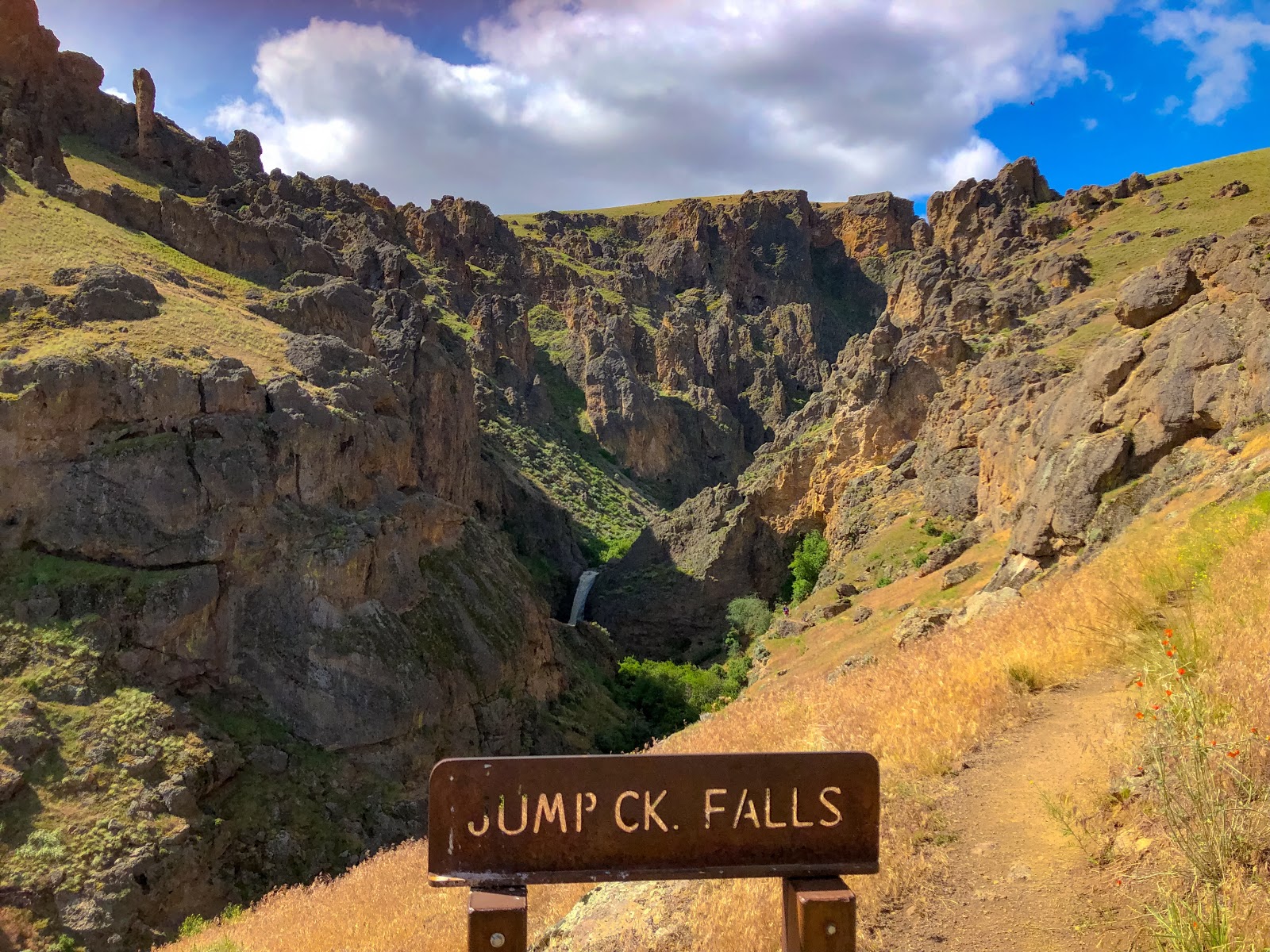
So we heard about this falls the "Jump Creek Falls". We googled it and photos looks great so we decided to visit. It was in the middle of May when we visited it and there was rain during that week. It was a lil bit chilly also.

This place is so beautiful, when we get there we choose to hike upper area to see the falls first and then after we planned to go down to the tip of the falls. Hiking up was really a struggle specially when you dont have the right shoes for hiking. It was so steep and a the soil is a lil dry. I am so afraid that i will roll over to the cliff. I had to stop so many times trying to figure out every step i made lol. I did not made it near to the falls as i am really scared lol.

After that hike we decided to go down to the other trail to see the falls closely. As usual we are not prepared, since it rained that week the volume of the water was a lil bit strong and the water was almost above my knee. By the way you have to crossed that water first before you can actually see the falls. The water was cold and we dont have extra shoes with us :(. We backed out and just better luck next time. 

We really want to go back and swim in there because a lot of people do swimming during summer. It was such a beautiful place. We love it there :)

Jump Creek Falls is a waterfalls locate in Owyhee County, just to the southwest of the city of Marsing, Idaho. The falls are accessible by a short, ​14-mile hike from a lower parking lot, while an upper parking lot offers several trails that explore the falls and surrounding areas.

Jump Creek Falls

Jump Creek Falls

Jump Creek Falls

Jump Creek Falls

Jump Creek Falls

Jump Creek Falls

Jump Creek Falls

YOSEMITE NATIONAL PARK

Another dream come true, seeing Yosemite in person is just so ahhh i cant contain it. I am just so happy to finally see it with my own eyes, those big rocks and a lot of falls, it was so awesome. 


Yosemite National Park is an American national park located in the western Sierra Nevada of Central California, bounded on the southeast by Sierra National Forest and on the northwest by Stanislaus National Forest. The park is managed by the National Park Service and covers an area of 747,956 acres (1,168.681 sq mi; 302,687 ha; 3,026.87 km2) and sits in four counties: centered in Tuolumne and Mariposa, extending north and east to Mono and south to Madera County. Designated a World Heritage site in 1984, Yosemite is internationally recognized for its granite cliffs, waterfalls, clear streams, giant sequoia groves, lakes, mountains, meadows, glaciers, and biological diversity. Almost 95% of the park is designated wilderness.
On average, about 4 million people visit Yosemite each year, and most spend the majority of their time in the 7 square miles (18 km2) of Yosemite Valley. The park set a visitation record in 2016, surpassing 5 million visitors for the first time in its history. Yosemite was central to the development of the national park idea. Galen Clark and others lobbied to protect Yosemite Valley from development, ultimately leading to President Abraham Lincoln's signing the Yosemite Grant in 1864. John Muir led a successful movement to have Congress establish a larger national park by 1890, one which encompassed the valley and its surrounding mountains and forests, paving the way for the National Park System.
Yosemite is one of the largest and least fragmented habitat blocks in the Sierra Nevada, and the park supports a diversity of plants and animals. The park has an elevation range from 2,127 to 13,114 feet (648 to 3,997 m) and contains five major vegetation zoneschaparral and oak woodland, lower montane forest, upper montane forestsubalpine zone, and alpine. Of California's 7,000 plant species, about 50% occur in the Sierra Nevada and more than 20% are within Yosemite. The park contains suitable habitat for more than 160 rare plants, with rare local geologic formations and unique soils characterizing the restricted ranges many of these plants occupy.
The geology of the Yosemite area is characterized by granitic rocks and remnants of older rock. About 10 million years ago, the Sierra Nevada was uplifted and then tilted to form its relatively gentle western slopes and the more dramatic eastern slopes. The uplift increased the steepness of stream and river beds, resulting in the formation of deep, narrow canyons. About one million years ago, snow and ice accumulated, forming glaciers at the higher alpine meadows that moved down the river valleys. Ice thickness in Yosemite Valley may have reached 4,000 feet (1,200 m) during the early glacial episode. The downslope movement of the ice masses cut and sculpted the U-shaped valley that attracts so many visitors to its scenic vistas today.
The name "Yosemite" (meaning "killer" in Miwok) originally referred to the name of a renegade tribe which was driven out of the area (and possibly annihilated) by the Mariposa Battalion. Previously, the area had been called "Ahwahnee" ("big mouth") by indigenous people. (Wikipedia)


We still wanna go back and do some hike. Its so beautiful right? I know my picture does not do the justice of how beautiful this park. I am only using my phone. But still its beautiful. :) 

Featured Post

City of Rocks National Reserve - Idaho

I been wanting to see City of Rocks during Fall Season and finally I did it this year. We drove to the Castle of Rocks then to the City of R...